
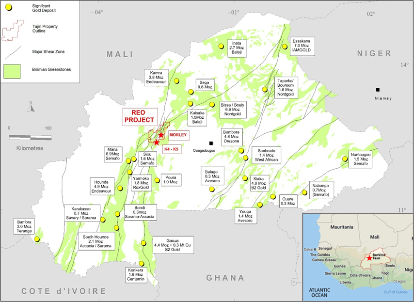
Tajiri purchased 100% interest in the Reo Gold Project in late 2018 as it provided investors exposure to a regional scale discovery opportunity within one of the fastest growing and mining friendly jurisdictions in the world. The exploration licenses that make up the project cover 1,002 KM2 of a confluence on the prolific Houndé and Boromo greenstone belts that just within Burkina Faso hosts several multi million ounce deposits like Karma 3.8Moz, Bissa 6.6Moz, Hounde 4.9Moz and Mana 8.6 Moz (reported inclusive of all P&P reserves and all M,I&I Resources). US$8 million in exploration had been spent on the property prior to the purchase by Tajiri and defined a plethora of targets through large scale geochemical and project wide airborne magnetic surveys, however, of the numerous potential targets only two prospects(Morley and K4/K5) were advanced to drill stage and will therefore continue to be priority targets moving forward.
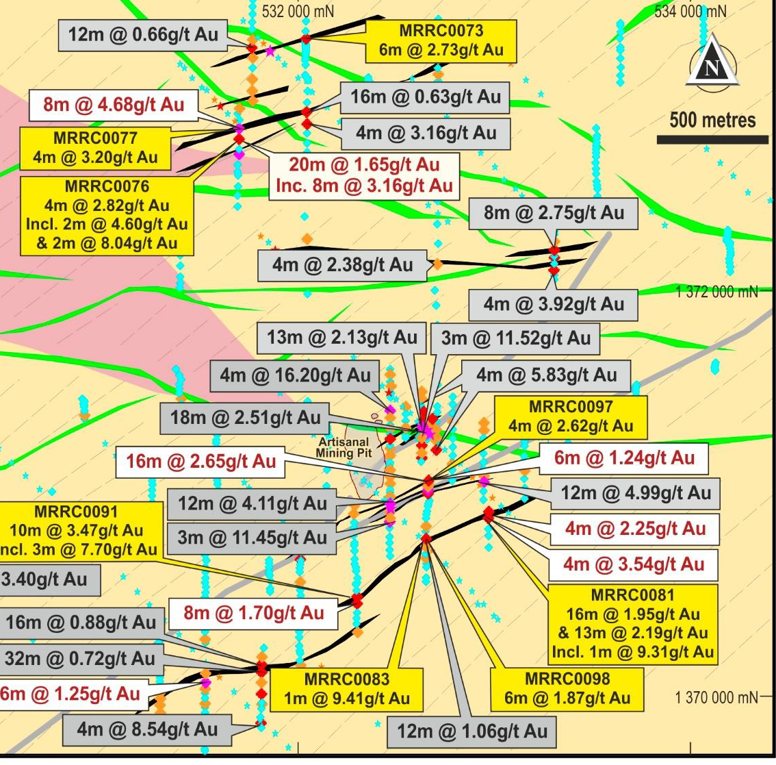
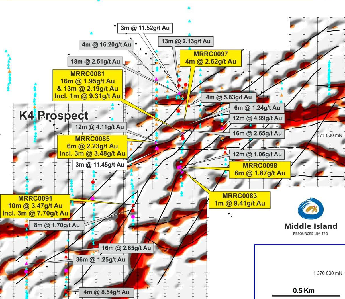
The K4-K5 Prospect – The focus of a majority of the previous work on the project was discovered as a result of large regional geochemical sampling over areas of extensive artisanal mine workings. Eventual drilling produced a huge amount of widely spaced results over an area of 7 x 6 km2.
Most recently following the renewal, on September 26, 2022, for a full 9 year term, of the license that covers the K4/K5 Prospects the Company has begun to release results from the ~18,000 metre auger drill program completed over the prospects between November 2020 and May 2021 with the first of those announcements having been released October 26, 2022, available for review (Here). The Company further released, after extensive review of all available data, a significantly updated geological model covering the entire K4-K5 Prospect. The results of the findings in this new modeling show the clear potential for the prospects to host a large to super giant gold deposit based on the highly mineralised and total scale (14 km x 6 km)of complex poly folding present and its similarities to other world class West African Gold Mines. The announcement is available (Here) – the key findings are summarized below with figures in support of the model.
Geological Setting
An extensive review of all data which included the construction of a new lithology map for the project, interpretation of multiple satellite images, and interpretation and re-processing of all propriety geophysical data sets and a review of publicly available gravity and magnetic data, has revealed several features that control the form and potentially influence the scale of mineralisation present at K4-5.
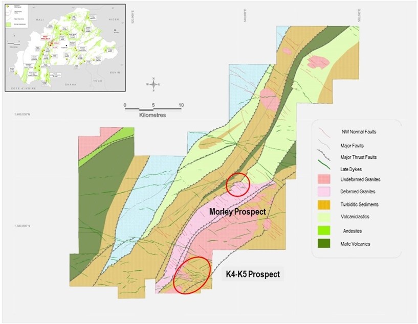
The setting of the K4-5 gold system is shown in Figure 2. Key features of this are in accord with potential for the discovery of a major gold deposit:
- It lies at the complex triple point junction of the Hounde, Boromo and Goren Greenstone belts and associated great structural complexity
- It lies within a region of major regional crustal scale trend change and flexure
- It lies on the flanks/at the tip of a major intermediate- basic volcanic complex which appears to be complexly infolded / thrust transported extension of the Hounde Belt. This location on the flanks of a major volcanic centre is associated with the many of the larger Birimian gold deposits.
Another key finding of the review was the recognition of a strong fold control to mineralisation at K4-5 which appears to be associated with complex compound type II interference patterns (See Appendix I Figure D for explanation), formed by the superposition of at least three phases of folding. A late phase F3 which strikes NNW, F2 which is tightly to isoclinally folded around F3 and an earlier phase of folding F1 which is difficult to trace for any distance, but is quite observable through the formation of fold interference patterns from F1 interactions with both F2 and F3.
Given the newly discerned structural controls (evident across many data sets) much mineralisation is now seen to strike subparallel to principal sampling directions – soil and saprolite auger samples were taken on mostly 400m -200m spaced NW oriented lines and historic drilling on either NW or NS oriented lines.
This leaves a lot of further potential at the K4-5 prospect which exhibits long kilometric scale zones of low order anomalism striking NW- NNW that may be representative of significant but poorly sampled mineralisation.
Results.
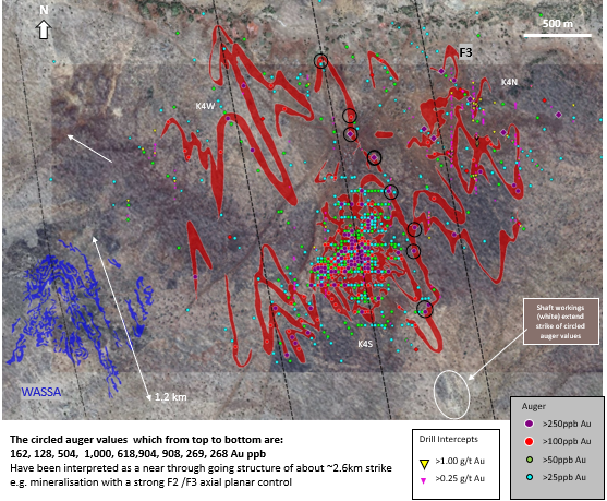
Results of our saprolite auger sampling campaign that immediately extends mineralisation reported previously at K4 South is presented in Figure 4 and Figure 5. This includes the prospects K4 North and West which combined with South comprise the K4 Prospect. Of note is that considering our recognition of the larger K4-5 Gold system, close spaced auger sampling by the Company has covered less than ~20% of the total prospect.
Interpretation
An interpretation of results to show a mineralised envelope containing substantively >100ppb saprolite auger results and >250ppb intersections in historic drill holes is shown in Figure 6 and Figure 7. Here, given that sampling is in substantial part oriented subparallel to interpreted strike of mineralisation, we have extended mineralisation to follow the form of interpreted lithological contacts which are largely influenced by F2-F3 folding and F2 and F3 fold axes (See Figure 7 for our provisional interpretation of major fold axes at the K4 prospect).
In the above mentioned Figures, we show a side by side comparison of K4 to the 13Moz Wassa deposit, which as noted in our previous announcement is the only other documented example of a poly folded gold deposit hosted within the Birimian of West Africa. Both look remarkably similar in form yet K4 (representing ~ 20% of the larger K4-5 system) has a footprint that is ~ 3-5 times larger than Wassa’s.
Evidence
The interpreted fold scheme for K4-5 has largely been based on interpreting visible folding evident in multiple satellite images as documented in Appendix I notes to Figure 7. Evidence to support our interpretation that the K4-5 system is a large poly-folded gold system is documented in the following Figures:
- Figure 8. Workings at K4 South are configured into the distinct arrowhead shape of a Type II fold interference pattern. This is made particularly evident in later Sentinel 2 imagery which post-dates imagery shown in our October 26, 2022 press release (Also see Appendix I Figure B). In addition, forms evident in a gradient array IP section line, which is near co-incident with the central F3 controlling fold axis of the K4 South workings appear strongly supportive of the interpreted fold scheme.
- Figure 9. A new lithological map of the area has been constructed, based on a discriminant analysis of XRF multielement ratios. The new lithological map is broadly and at larger scales supportive of the interpreted fold scheme.
- Figure 10. Overall form of the K4-5 gold anomalism as expressed in more dispersed soils is supportive of the fold scheme and echoes regional forms visible in magnetics.
- Figure 11. Horizontal gradient magnetic data measured by gradiometry- a good way to examine lithological contacts in higher resolution than filtered TMI data alone is strongly in agreement with the fold scheme interpreted from satellite data. As this data is from a survey flown at 100m line spacing on N-S lines it does lack some resolution of tighter folding and is in part somewhat aliased by the NS line orientation being subparallel to NNW F3 fold axes.
The Company is currently in the planning stages of the follow up program that will be intended to further expand and test this new model with exploration work to include a significant amount of drilling as well as additional sampling trenching and geophysics.
Comparatives and Workings
As part of an extensive review of K4-5 we have mapped and aggregated all workings visible in 13 publicly available high resolution satellite images dating between 2008 and 2023 with supplemental mapping from lower resolution Aster and Sentinel images. This allowed a compilation of the outlines of all workings, both surface lateritic and bedrock shafts from over 13 years of near continuous artisanal activity to be compiled. All workings are shown in Figure 13 and a logical relationship to interpreted folding appears evident.
For the purposes of comparison, a similar exercise, reviewing multiple satellite images and compiling evolving outlines of artisanal workings, was conducted at a number of gold deposits with reported resources/reserve throughout Burkina Faso and Northern Ghana. An example of such review and comparison to current mining and drilled resource outlines is presented in Figure 12.
In general, a high correspondence between areas of mineralisation outlined by artisanal bedrock shafts and later drilled resource outlines was found. Figure 12 shows M1 South and Sanbrado demonstrates the very close correspondence between areas outlined by artisanal shafts and the outline at surface of drilled resources. In this case the variance is <10%. This finding allows a reasonable indication of potential deposit size to be gleaned from the extent of bedrock shaft workings.
A comparison of artisanal workings overlying example 4-7Moz Burkina and Northern Ghanaian gold deposits and K4 is shown in Figure 14.
During the course of the comparison of the exercise, it was found that both the K4 North and K4 South areas of bedrock shafts are much larger than any one image might show. At K4 South because shaft sinking has been episodic but with near continuous periods of lateritic surface working – including mechanical working which tends to back fill or otherwise disperse shaft spoil obliterating evidence of earlier shafts. While at K4 North, all shafts since 2015 have been sunk off the bottom of a large 5-10m deep pit of about ~ 100,000 m2 from which all lateritic material was removed mechanically and sluiced at nearby creeks. This rather sizable pit floods during the wet season, with shaft sinking now only taking place for ~ 4-6 months of each year during the dry. After each wet season many artisanal shafts are found to have collapsed and shaft spoil is often masked by a coating of lateritic clay obscuring the true extent of shaft workings at K4 North in any one image. Of note the more extensive shaft workings at K4 South, than initially suspected, may have negatively impacted the tenor of results returned by our auger drilling as it is possible that extensive areas of higher-grade mineralisation has been removed.
Across Burkina it was also noted that shaft workings that exploited mineralisation known to be of higher grade were generally deeper as shown by the darker colouration of surrounding shaft spoil (i.e. shafts had gone deeper into less bleached saprolite chasing higher grades) and higher grade areas were generally (but not universally) surrounded by large areas of shallow lateritic surface workings. The later feature is possibly a result of the greater coarse gold content of higher-grade deposits which upon weathering forms an extensive deflation lag far more amenable to the crude wind winnowing method used for recovering gold from surface workings in Burkina.
Of note the K4 North shaft workings show the features indicative of potentially high grade mineralisation which is further supported by the fact that shafts have been worked for a long time- continuously from 2010-2015 and then seasonally from 2015- present. Further in support of the high grade potential of the K4 North shaft workings is that the area has due to sample orientations hardly been sampled but the one historic drill hole which did interest the edge of these workings returned 4m @ 16.2g/t from 4m.
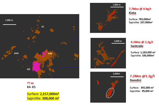
Finally, Figure 15 compares the size of saprolite geochemical anomalies present at K4-5 with those overlying known 4-7Moz deposits and with reference to Table I it is clear that K4-5 is of a scale at various threshold levels that is between 1.5 and 9 times the size of those peers.
The Morley Prospect
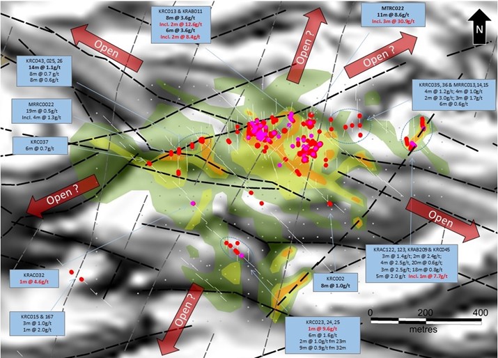
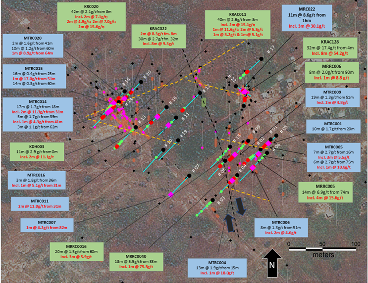
The Company recently completed its first pass effort of just under 2,000 metres of RC Drilling resulted in the following significant intercepts:
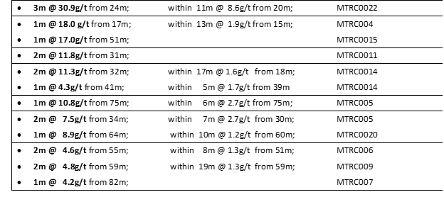
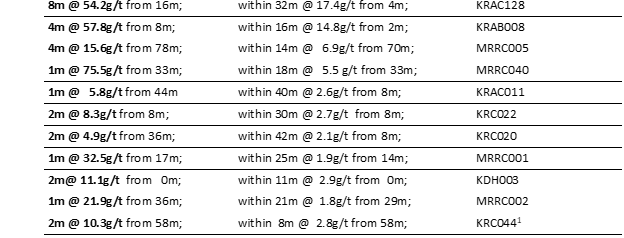
Though Morley is still at an early stage it continues to show potential to host a gold deposit of economic merit through Tajiri’s recent expansion drill program combined with the body of historical drill results below:
The recently completed drilling has provided information of major significance in the understanding of the mineralization at Morley summarized as follows:
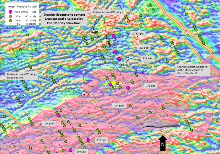
- Tajiri’s maiden drill program confirms a new orientation model for gold mineralisation at Morley which is situated in a belt scale deformed granite and lies within 800m of the northern and 1,000m of the western granite-greenstone contact (Figure 1).
- Tajiri drilling shows the main mineralised zone at Morley has a WNW strike and dips -50˚ northeast. Strike is sub-parallel to a set of crosscutting shear zones which occur over a width of about 2km at Morley and are axial to a major 40˚ flexture in the strike of the granite-greenstone belt from ENE to NNE (Figure 6).
- Importantly confirmation of the Company’s new model opens-up on strike and down dip potential into very sparsely explored or totally unexplored areas both immediately and further along strike (Figures 4,5 & 6).
A very favorable target is now in play: only 1,000m WNW along strike, the “Morley structure” cross cuts the ENE trending sheared granite-greenstone contact of the Morley host granite. Empirically, granite-greenstone contacts are a favoured location for high grade gold deposits in Burkina such as M1 South, Siou and Yaramoko (Figure 6).
Burkina Faso has rapidly become the third largest Gold producing nation in Africa having had more than 12 major gold mining projects come into production over the past 10 years, underlain by two of West Africa’s premier greenstone terrains it provides ideal conditions for gold exploration and development with a high probability of success. A mining friendly government regime, highly capable and well educated local workforce all provide for one of the worlds premier exploration and mining jurisdiction.